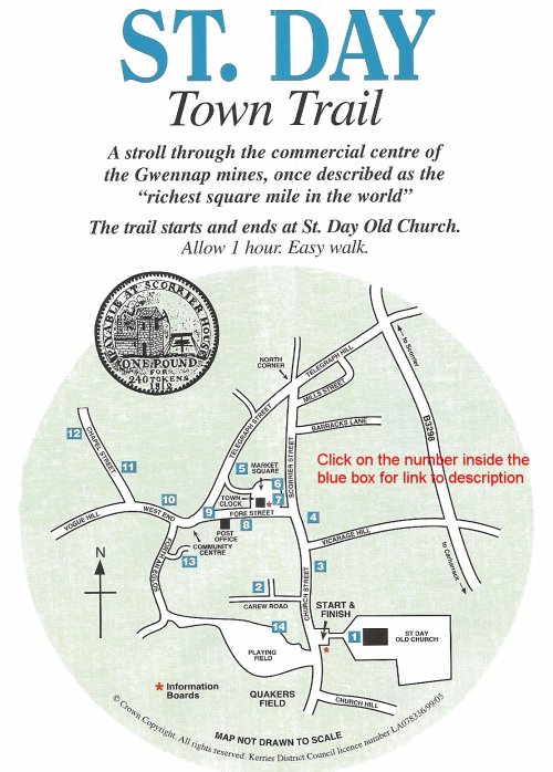
1. ST. DAY OLD CHURCH
A place of worship from 1829 until it was abandoned in 1956. Unusually the original interior has a gallery. Today the church is a community venue with an exhibition about local history inside.
From the Old Church turn right into Church Street, then first left into Carew Road.
2. THE OLD RESERVOIR
Built for £700 in 1828 within the grounds of Carew House to supply water for domestic use and fire fighting. Water was raised by water wheels from a spring at Five Shutes and pumped through iron pipes to the reservoir, then to a pump in the Potato Market opposite the Town Clock.
Return to Church Street and turn left.
3. CEDARS LODGE
This pentagonal building was constructed in the early 19th century of cut granite ashlar. It was associated with the adjoining 18th century house ‘The Cedars’, the residence of Collan Harvey whose family were wholesale merchants for the mining industry (see trail point 8). The gates next to Cedars Lodge led to the associated stables and coach houses. Continue along Church Street passing the junction with Vicarage Hill. The next tall shop building, on your right, was a Chemist & Druggist until the 1930s, run by the Corfield family from the early 19th century. Across the road, look for two deep depressions in the granite kerb, now filled with tarmac. These helped backing wagons into a 19th century store. A little further along before the next junction, note the tall building on the right, now two dwellings. This was the home of William Wilton, Scientific & Mathematical Instrument Maker whose products were sold worldwide. His other office was in Valparaiso, Chile, where he moved to in 1876.
4. SITE OF ‘MARKET INN’
In 1847 the Market Inn’s landlord was Joseph Grenfell. Later it was converted into two houses, indicated by the single lintel over the two doors. Continue along to Scorrier Street. The first tall house on the right was Richard Thomas’ ‘Watchmaker & Jeweller’s Shop. Later it became one of T. R. Mills’ two ironmonger’s shops. A little further along Scorrier Street, on your right and set back from the road, is the former Primitive Methodist Chapel. This was built in 1885 on the site of a single storied thatched Baptist Chapel which was later used as the Town Hall and a Temperance Hall. Note Barracks Lane on your right. The building you see facing you as you look down the lane was the Salvation Army Barracks in the 1880s. Next is Mills Street built in the 19th century to house miners and named Simmons Street. Today the street retains its original character and is listed for its architectural interest. Now owned by Mills Cottages Trust “for the old, poor and needy of St. Day”. Note the bronze plaque in the dummy window on your right, as you look down the street.
You are now at North Corner and from here turn left into Telegraph Street (known as Pig Street in the 1800s). The large houses here were built in the late 19th Century for the more affluent members of the community such as doctors, mine captains, engineers and entrepreneurs.
5. THE MANOR WORKSHOP
Note the narrow glazing bars on this listed building, a common practice in builders’ workshops right up to the early 20th century. This cost saving method allowed glass to be cut from small oddments to fit the window.
The adjoining building on the left and the cottage opposite are both shown on the 1772 plan of St. Day.
Take the alleyway on the left into Market Square.
THE TOWN CLOCK
Built in 1831 for £400. The present bellcote was added in 1904 when it was removed from Redruth Town Clock. The ground floor was used as a ‘clink’ to lock up drunks. Stocks were sited here up to about 1880.
THE MARKETS
In 1798 work started on building a covered market that almost filled the square and remained here until 1911. The Fish Market was in the now privately owned yard on the east of the square. Granite pillars here are evidence of the covered area. Williams Court opposite, was once the Potato Market, or “Tatey Court”.
6. THE FORMER CHEMIST SHOP
From the late 18th century to the middle of the 19th century this was a Chemist Shop. Thomas Sleeman, druggist, died here in 1831 and his headstone can be seen in the Old Churchyard. The shop became a Doctors’ Surgery in 1857 and remained so until 1950. The 1847 Williams Directory of Cornwall lists 63 businesses in St. Day, including two doctors and two chemists.
7. THE OLD POST OFFICE
Opened in 1830 ten years before the introduction of the Penny Post, it remained a Post Office up to 1969. Joanna Tiddy was the first postmistress. Later it housed the first manual telephone exchange for the St. Day area.
From the square, turn right into Fore Street.
8. CAREW HOUSE
This is the back entrance to a once important residence occupied by James Harvey in the mid 19th century. His brother Collan lived in The Cedars (see trail point 3). The large building opposite was originally their warehouse and is now the Masonic Lodge.
Continue to the junction with Telegraph Street.
9. SITE OF THE MEDIAEVAL CROSS
A mediaeval cross once stood at this junction. It stood well out from the corner and its removal, sometime between 1772 and 1825, widened the road for increased mine wagon traffic. The sloping granite corner stone was probably put here at the same time to stop wagons from damaging the building. Continue along Fore Street towards West End. On the right of the Community Centre is part of a 17th century “z” shaped building. Look the for the gable end with built-up windows and doorways that indicate the remaining house was once larger. Originally it would have extended across the plot occupied today by the Community Centre and the house to its left.
Continue along West End and a little further along on your right is the Trinity Chapel.
10. SITE OF TRINITY CHAPEL
This was the site of the first church building in St. Day and probably the first Christian Cell. The chapel is mentioned in Bishop Bronescombs’s (of Exeter) Register of AD 1269. It was closed during the Reformation and the tower was finally demolished in 1798. Note two small mediaeval crosses in the conservatory wall either side of the door.
Continue along West End Before turning right into Chapel Street look across the valley for the engine house straight ahead of you. This is St. Aubyn Mine which was worked from 1843 to 1893. Turn right into Chapel Street.
11. FORMER WESLEYAN CHAPEL
The two tall houses nearly half way down on the right were originally the first Wesleyan Chapel in St. Day. Look for the 1828 date stone in the front centre of the building, this is also likely to be the date the street was built.
Continue to the end of Chapel Street.
12. DOWNING’S SCHOOL
The last two houses on the left were used as a Boys’ School, kept by William Downing, as shown in the Tithe Apportionment Book of 1839. Return along Chapel Street and turn left. Take the first turning on your right into Forth an Eglos. Note the site of the Blacksmiths Shop on the right-hand corner, there had been a Blacksmiths Shop here ‘with dwelling over’ from the late 1680s until the late 1930s.
Then turn into the short lane on your left before the big house.
13. THE GIRLS’ SCHOOL
In the 19th century a school occupied the small building facing you. “Here were two rooms one above the other, but the lower room – very commodious – was a slaughter house with all its appurtenances, and access to the girls’ school was up a stairs in the slaughter house”. (from RR Blewett, ‘These things have been’).
Retrace your steps back into Forth an Eglos (“Street of the Church”).
The new houses straight ahead of you were built on the site of a Wesleyan Chapel (1844-1968).
Turn left along Forth an Eglos. The high wall on your left enclosed Wheal Quick mine buildings. In the 19th century, Wheal Quick became part of Wheal Jewel. From 1815 -1853 the mine produced 58,000 tons of copper ore, 9 tons of black tin and 20 tons of lead ore. Leave this road where it bears right downhill, take the left path to Wheal Jewel children’s playing field. Then follow the path passing in front of the row of houses. Go past Jewel Cottage and stop at the wooden gate to the left.
14. THE NATIONAL SCHOOL
Look through this gateway. Note the building on the left with stone steps leading to the upper floor. This was a school for girls and boys run by William Rickard, Master, and Mary Dingle, Mistress.
Opposite the open playing field lies a roughly triangular field described in the 1682 survey as ‘The Three Cornered (sic) Field’ and ‘The Quakers Field’. Three Quaker families (Goldsworthy, Reynolds, & Hitchins) are recorded as living in the Manor of St. Day during the 17th & 18th centuries.
Turn left to return to where you started at the entrance to St. Day Old Church.
Copyright St Day Parish Council ©2010 | contact council@stday.org